Beware of dangerous weather on land and at sea.
The government and people need to closely monitor weather developments and respond according to the "4 on-site" motto (on-site command,
on-site forces, on-site means and materials, on-site logistics).
On May 11, according to information from the National Center for Hydro-Meteorological Forecasting, dangerous weather patterns will appear on land and sea.
To proactively prevent and reduce damage, the government and people need to closely monitor weather developments and respond according to
the "4 on-site" motto (on-site command, on-site forces, on-site means and materials, on-site logistics).
Northern and North Central regions cool down, high waves, strong gusts at sea
According to Deputy Head of Weather Forecasting Department, National Center for Hydro-Meteorological Forecasting Vu Anh Tuan, cold air has
affected the Northern region, most of the North Central region. In the Gulf of Tonkin, there are Northeast winds at level 7, gusting to level 8.
According to the forecast, in the afternoon and night of May 11, cold air continues to affect other places in the North Central region and some places
in the Central Central region. Inland, Northeast winds at level 2-3, coastal areas at level 3-4, gusting to level 6.
The North and North Central regions are cool, and some mountainous areas in the North are cold. The lowest temperature during this cold air wave
in the North and North Central regions is generally from 20-23 degrees Celsius, and some places in the high mountainous areas of the North are
below 19 degrees Celsius.
Hanoi area has occasional rain and cool weather. The lowest temperature in this cold air mass is generally 21-23 degrees Celsius.
Cold air can cause a strong drop in temperature that can affect health such as increasing respiratory and cardiovascular diseases due to sudden
temperature drops, especially for the elderly and children.
At sea, on May 11, the Gulf of Tonkin has northeast wind level 5, sometimes level 6, gusting to level 7, rough seas, waves 1.5-2.5m high.
The northern sea area of the North East Sea has strong northeast wind level 6, gusting to level 7-8, rough seas, waves 2-3m high. The wind
gradually decreases at night.
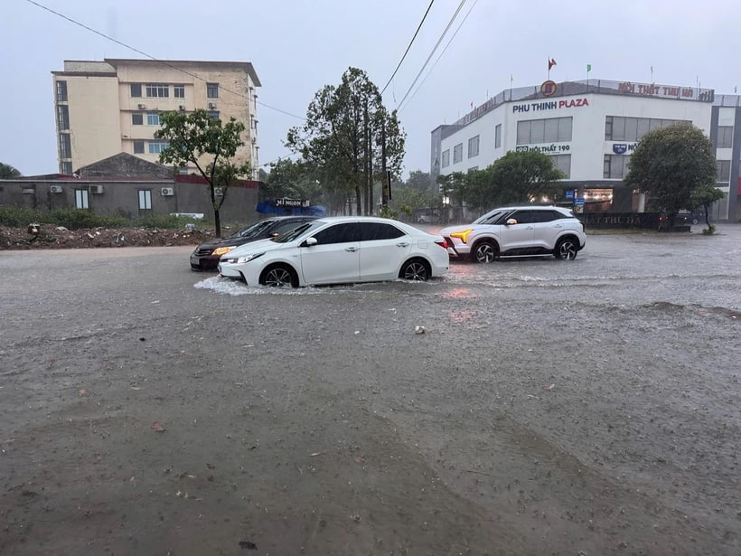
Heavy rain in the Central, Central Highlands and Southern regions
Commenting on the rain situation, Mr. Vu Anh Tuan said that on May 11, the area from Ha Tinh to Quang Nam has moderate rain, heavy rain
and thunderstorms, locally very heavy rain with widespread rainfall from 20-50mm, some places over 100mm. Rain gradually decreases at night.
Warning of the risk of localized heavy rain over 80mm in 3 hours.
In addition, in the afternoon and evening of May 11, the Central Highlands and the South will have rain, moderate rain and thunderstorms,
locally heavy rain with rainfall of 15-35mm, some places over 60mm.
Warning of heavy rain in the areas ending on May 12, during thunderstorms there is a possibility of tornadoes, lightning, hail and strong gusts of wind.
Natural disaster risk level due to heavy rain level 1
Heavy rain is likely to cause flooding in low-lying areas, urban and industrial areas; flash floods on small rivers and streams, landslides on steep slopes.
From the night of May 10 to this morning of May 11, the Northern region and Thanh Hoa to Quang Binh will have moderate rain, heavy rain and thunderstorms,
locally very heavy rain. Rainfall from 7pm on May 10 to 8am on May 11 was over 150mm in some places such as: Minh Hoa (Thai Binh) 156.6mm,
Yen My (Thanh Hoa) 230.4mm, Que Phong (Nghe An) 199.4mm, Tan My (Quang Binh) 180.8mm./.
ESOMAR Global Research Company will continue to update the latest news on the global market.
ESOMAR Vietnam Representative Office:
Address: 82 Nguyen Xi, Ward 26, Binh Thanh, Ho Chi Minh City
zalo:+84918082815
Contact Phone: 02855598501
Email: [email protected]
Official website (https://www.researchworld-vnm.com/)
Esomar VNM (https://esomarvnm.com/)